Tuesday, September 27, 2011

Cuenca

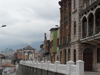
Down in the Southern highlands just a few hours from the Peruvian border, downtown Cuenca surpasses even Quito's Old Town for its European feel. The narrow stone streets lead up to a least a dozen churches. The streets seem to go on for ever, so the area takes at least an hour to cross in any direction.

A street in downtown Cuenca on an early Sunday morning

At the center of the old town is a lively park called Parque Calderon, which sits in front of the Catedral de la Inmaculada Concepcion, the largest and most spectacular of the churches (though actually one of the newest at only 125 years old). The oldest churches date back to the 16th century.

There really isn't a good place to get a picture of the entire Catedral from. Here's the top.


The edge of downtown Cuenca. The river is just off the edge of the picture at the left.

Another church

This is outside a cafe in a part of town that's under renovation but they hope will become a mini Greenwich Village.


A street called the Calle Larga overlooks Rio Tomebamba, which divides the old and new sections of town, at least in one direction. Downriver is a gorgeous forested park with a very elaborate system of wooden walkways in places. Just on the other side from downtown is the university as well as the majority of Cuenca's 400,000 people.

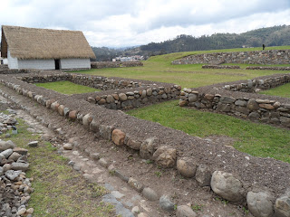
At the very edge of the historical center on the Calle Larga there are still ruins from the Incan city of Tomebamba, which can be walked through anytime the Pumapungo museum is open. The museum itself has five of the creepy shrunken heads from the Shuar people of the Oriente. There are about a dozen other museums in town as well, dedicated to everything from Incas and other pre-Spanish civilizations to modern art.

What's left of Pumapungo. The ruins cover an entire hillside.

The downtown also has a huge daily market where you can get all the vegetables, fruits, grains, meat -- anything you need. It covers two entire city blocks, two stories high.

A woman who was nice enough to pose for me at the market.


Friday, September 23, 2011

The Oriente

The geography of Ecuador is truly spectacular if you are not a bus or a grazing animal. A small country with the Andes running through the center, the country is filled with peaks and valleys. Farmland is rarely if ever terraced and covers many of the hills like a green patchwork quilt thrown over the land. A trip of 50 kilometers often skirts many hills and requires many climbs and descents.

One of the most striking features is the swift change in landscape on the Eastern slope of the mountain range. With the briefest of transitions, the cool mountain air and sparse, almost tundra-like atmosphere gives way briefly a to temperate climate and, just a short distance later, to the humidity and lush foliage of the jungle.


The view from a bit above the jungle


Ecuadorans have dubbed the area the Oriente, and it is the western-most part of the Amazon Rainforest. It extends for hours from a number of cities at the edge, and there are cities deep within that can only be reached by small airplanes.

In the jungle

Tena is one of the biggest jumping off points for adventures in the Oriente. A city of about 28,000, is a hub for both jungle and rafting adventures. It has a small square at the center of town and a few downtown blocks, as well as development on the other side of a footbridge where much of the commercial activity takes place. Two rivers, the Rio Tena and Rio Napa, meet right near the footbridge.

Long live Tena


The eastern slopes and the jungle are also home to the native Kichwa people, and most jungle tours also involve a visit to a Kichwa village. The Kichwa take great effort to keep the culture alive and some children learn the Kichwa language before Spanish. This will be explored at greater length in later posts.

Monday, September 19, 2011

Baños

Baños
One of the first stops down on the way to the Oriente, Baños has a bit of everything. The town sits in the shadow of Volcan Tungurahua, which was bad news during the two main eruptions over the past 12 years.


Rio Pastaza
While the town's main claims to fames are the thermal baths for which it gets its name and as a jumping off point for dozens of outdoor activities, the area itself is quite stunning. It sits in a valley with high ridges on either side and the Rio Pastaza cutting through town. Further down the road are about a dozen waterfalls, mostly visible from the road.


Pailón del Diablo

The elevation is only 1,800m, making the hiking, and biking, a little easier. The road down to Puyo 60km below is great for biking down (though not up). The town itself is very touristy. The area around the Basilica de Nuestra Señora de Agua Santa is always busy and filled with vendors. The church itself is quite impressive, especially when it is lit up at night.


Making taffee

Thursday, September 15, 2011

The Climate in Ecuador

It is hard to describe the climate of Ecuador without beginning with the sun, which hasn't appeared that often. Partly cloudy days can be very tricky, as the sun is so intense the temperature can raise about 20 degrees (Fahrenheit) when it peeks out from behind a cloud.

Thus far, after about three weeks in the country, the weather has not been hot at all. In fact, given that most places in Ecuador are without heat, thermal underwear has been more essential than shorts. When it is out, however, the sun is quite intense and can burn after half an hour. Even cloudy days require sunscreen and most of the people wear hats. It seems for the most part locals dress for the cold and just suffer when the sun is out. It is a weird effect to have the sun, at noon, almost directly overhead. It always rises between 6 and 7 and also sets between 6 and 7 in the evening.


In the mountains, the setting of the sun means a big drop in temperature. Most places are still heated with firewood or not heated at all. Temperatures don't get down to freezing, but with the thin air it can get quite chilly. The alpaca sweaters and ponchos are popular for a reason.


Even the jungle was not that warm, despite being below 1,000 meters in elevation, though the locals said that was not always the case. It can get quite humid at times, but for the most part over five days it was very pleasant. It rained hard at night a couple of times, but very little during the day. Once again, the temperature difference was huge depending if the sun was behind a cloud.

Monday, September 12, 2011

The Quilotoa Loop

Whoever first came up with the idea of this Loop is a genius in marketing. It really is a great way to see some very rural, and incredibly beautiful, Ecuadoran landscape.


The Southern Part of the Loop

The Loop covers the area southwest of Quito, still in the highlands. The single natural highlight is Quilotoa Lake, a volcanic crater nearly 400 meters deep filled in at the bottom with a lake that, when the sun shines, looks green. A spectacular view from above (a 6-hour hike will take you around the top) or at lakeside (an hour either by foot or donkey will take you down).


Quilotoa Lake

The first stop on the clockwise journey, however, is Tigua, a little village with some amazing artisans who in some cases create their next masterpiece in the store while customers shop. Next is Quilotoa, a tiny little town with little to offer beyond the lake and the view (you can see Cotopaxi and both Iliniza peaks). Only about 150 people live there, and all seem to be in the tourism industry. The women wear traditional clothing, high heels and hats that look like fedoras.


Another spectacular view

A good hike or bumpy car ride down the road brings up Chugchilan, a cute little village and gateway for hikes to several other rural villages. Breathtaking scenery once again.

Chungchilan


The top part of the loop rivals the bottom in scenery, but there really aren't towns worth stopping at. The entire loop can be seen efficiently in two days or in a nice, relaxed week.


Northern Loop

A couple of quick lessons learned, however. Transportation can be a bit tricky and limiting to what you can see. It is possible to walk between some of the villages, or ride horses, but obviously plan ahead and bring only the basic necessities, which should include warm weather gear for nights. Or go the other way and rent a car. Then you can bring as much as you want and spend time wherever you please.

The Iliniza peaks are visible (clouds permitting) from the northern part of the loop

Friday, September 9, 2011

Cotopaxi

The area south of Quito includes many of Ecuador's most famous and amazing mountains, as well as a few active volcanos. Tungurahua, near Baños, has erupted three times in the past 12 years, but most of them have been silent for a long time. The signs of their activity are easily visible.

One of the most striking features of the majority of the mountains, and volcanoes, is they have neither snow and often don't even have snow line. Vegetation grows here at well over 3,500 meters.

That is not the case with the stunning Volcan Cotopaxi, the focal point of the Parque Nacional Cotopaxi. One of the world's highest active volcanoes at nearly 6,000 meters, it is gorgeous with a clear view though clouds almost always seems to obscure at least a bit of it. The area around is high plains, with mostly tall grasses though some pine trees manage to survive up to the gates of the national park.


Volcan Cotopaxi, with llama

Volcan Cotopaxi, without llama

From the entrance it is quite a hike just up to the bottom of the glacier, with winds quite chilly whipping through clothes. Very few attempt to go beyond the base of the glacier.


Sunset and early in the morning were about the only times the clouds cleared

The area surrounding the national park is mostly grazing land and only accessible through bumpy, 20-km cobblestone road from Machachi, the nearest town. Sheep, cows and llamas are the majority of the large livestock, with chickens and roosters also living in the area.

The view from the entrance to the National Park. The paths cut by the lava are visible.

These llamas were often kept in fields with sheep and cows, often with the purpose of providing protection for the other animals. In many cases their wool is not even used.

Monday, September 5, 2011

Ecuadorans

Like everywhere else in Latin America, or at least everywhere I've been, the Ecuadoran people are very friendly and welcoming. Also, like much of Latin America, they are a few inches shorter than Americans and Europeans. In several places, notably Cuenca, they seem to be living to an old age.

Ecuador features a blend of the future and the past in its population, with traditional dress blending seamlessly with modern clothes. Even some of the children wear the traditional Andean dress style. Baseball caps often replace the fedora-like hats worn by both genders. Women wear a shawl or sweater, traditional shirt, skirt and, in some cases, high heels (usually just in touristy places). Men wear ponchos, shirts and slacks.

I'll have greater insight as I get to know more people and see how they live, but for now here are a few pictures. The first three are from various markets in Cuenca.


Our jungle guide

An artist and his wife at their shop in Tigua

Kichwa (native) children in the jungle


Friday, September 2, 2011

Quito

Quito
The journey begins, as do most in Ecuador, in Quito, which seems to be the hub of the wheel. While Guayaquil down south is the largest city, many of the places worth visiting seem to be within a reasonable journey of the capital city. Further posts will bring descriptions and pictures of the jungle and the Andean Highlands, the Cloud Forest and the beach, and finally from the site of my volunteer position three hours southeast of Quito.


The hillside to the West of Old Town (the Centro Historico)
But first, Quito. The most striking feature of the city is that it is crammed in between rolling hills and mountains in the Andes, but spills up on to the hills. The capital has an Old Town (the Centro Historico) and a New Town, which contains an interesting area known as Mariscal. The city is overlooked by a large statue on a hill called El Panecillo, built fairly recently (1976) and reminiscent of Christ the Redeemer in RIo de Janeiro. From that hill, or another nearby hill topped by the Parque Itchimbia you get a great look at the Centro Historico.


El Panecillo
The most dominant feature when looking down from above is the Bascilica del Voto Nacional, named such despite the lack of an actual domed top. The gargoyles on this church are fantastic, with pairs of animals from the Galapagos.

Bascilica del Voto Nacional and Old Town

Check out the gargoyles when you blow up this picture
 Walk down the hill and within a few blocks you are in the heart of the Old Town, a 16th century European town mixed with modern Ecuadorian touches. La Ronda is a street that, with a little more money invested, could be located in any country in Western Europe.

La Ronda
 In addition, Quito's Old Town is where the government of Ecuador resides. The Grand Plaza is a perpetually bustling square with the president's house on the west side, the Congress on the south side and administrative offices on the East, surrounding a statue.

The Grand Plaza
 The rest of Quito seems to be on the nicer, cleaner end of big Third-World cities. There is quite a bit of noise and some traffic congestion, but you can get around. There are a lot of cabs which don't cost too much (most journeys are about $1-3, going up to $10 or so to get all the way across town). Buses are just a quarter and are very orderly. The pollution is noticeable and gas here is quite cheap (about $1/gallon for diesel, $1.50 for unleaded and $2 for super). It is definitely not up to first-world pollution standards, however.

One annoyance in Quito is they have two main bus stations and at least one other small one, which makes it very difficult to go through Quito on your way to somewhere else. You may have to take a city bus or taxi between bus stations.

I will leave the adventures outside Quito for the next blog entries.